Hazards
Field | Description |
Default Hazard Source | Selection of a hazard model will be triggered by the "Hazard Source" field within the UI.
Note: Contact support if interested in using the NFP avoid turbulence feature. |
OAT avoid temperature | Enter the threshold forecast temperature in °C. Forecast temperatures below this point will be avoided when generating a flight plan. Note: The OAT avoid temperature setting avoids the temperature if possible, and warns the user if it is unable to. |
Turbulence EDR threshold | Enter a maximum EDR (Eddy Dissipation Rate) value to avoid. Note: NFP will attempt to avoid EDR values above the value entered when generating a flight plan.
Refer to: https://navblue.freshdesk.com/a/solutions/articles/35000214227?portalId=35000062530 |
Avoid Turbulence | Options are Yes or No. Select Yes in the field beside to set the Avoid Turb checkbox on the Route Group and Avoid turbulence checkbox on the Route Builder screen to check by default. Note: See Plan and Route screen Defaults. |
Turbulence Severity Range | The following three fields allow you to set a turbulence range. These values are displayed on the flight plan. Light Turbulence TDR: Enter a light turbulence value - between 0.15 and 0.25. This value cannot be higher than the Moderate Turbulence value. Moderate Turbulence TDR: Enter a moderate turbulence value - between 0.25 and 0.45. This value cannot be lower than the light value or higher than the severe turbulence value. Severe Turbulence TDR: Enter a severe turbulence value - greater or equal to .55. This value cannot be lower than the light value or the moderate turbulence value.
|
Dest TS Warn | Select this checkbox if you want a warning to display on compute if the probability for a thunderstorm at the destination is 30% or greater based on the TAF. |
Icing PPI threshold | Enter a maximum Percent Power Increase (PPI) value to avoid. Note: N-Flight Planning attempts to avoid PPI values above the value entered when generating a flight plan. Allowable values are 0.0 – 2.0. |
Avoid Icing | Options are Yes or No. Select Y in the field beside to set the Avoid Icing checkbox on the Route Group and Avoid icing (if flying low) checkbox on the Route Builder screen will be checked by default. Note: See Plan and Route Screen Defaults. |
Max thunderstorm vertical velocity | Enter the vertical velocity value in meters per second. Note: Values above this point will be avoided when generating a flight plan. |
Thunderstorm fly over clearance | Enter a flight level in hundreds of feet. This allows the aircraft to fly above a thunderstorm by this value. |
Avoid Thunderstorm: | Options are Yes or No. Select Yes in the field beside to set the Avoid Storm checkbox on the Route Group and Avoid thunderstorm checkbox on the Route Builder screen will be checked by default. Note: See Plan and Route Screen Defaults. |
Data Buffers
Field | Description |
Tracks Before/After: | Enter a valid buffer time in minutes before ETD start. Enter a valid buffer time in minutes after ETA start.
|
SIGMET Before/After | Enter a valid buffer time in minutes before ETD (blank for no filtering). Enter a valid buffer time after ETA (blank for no filtering). Then, in the checkbox choose whether to filter SIGMETs on UI INFO/VIEW by ETD/ETA.
|
Notam Buffers | Enter a valid buffer time before ETD. If blank, 6 hours by default. Enter a valid buffer time after ETA. If blank, 6 hours by default. Then, in the checkbox choose whether to filter Notam on UI INFO/VIEW by ETD/ETA.
Note: - If the UI filter checkbox is not checked, the UI displays all NOTAMs.
- If the UI filter checkbox is checked, the UI displays a restricted subset of NOTAMs based on the times in the Before and After fields.
|
Company NOTAM Before/After | Enter a valid buffer time in minutes before ETD (blank for no filtering). Enter a valid buffer time after ETA (blank for no filtering. Then, in the checkbox choose whether to filter Company NOTAMs on UI INFO/VIEW by ETD/ETA.
|
NOTAM
Field | Description |
NOTAMs Display | Shows NOTAMS preference, options include: D= Domestic NOTAMS only d= International NOTAMS. If none, then domestic I= International NOTAMS only i= Domestic NOTAMS. If none, then international A= International NOTAMS and non-duplicate domestic o= Domestic NOTAMS and non-duplicate international a= Both international and domestic, including duplicates
|
Group by Q-Code | Options are Yes or No (no). If set to Yes, NOTAMS in flight package will be grouped on a per Q code basis and labelled accordingly. If set to No, NOTAMS will not be grouped nor labelled as such. |
Show Short Q-Code | Options are Yes or No. If set to Yes, short Q code labels will be shown. If set to No, they will not. |
Actioned Identifier | Enter a prefix to a NOTAM that is actioned. This means that the prefix is added to any NOTAM that affects the route used. |
Recent Identifier | Enter a prefix to a new NOTAM. This prefix is added to any NOTAM that is new. Note: If you enter a prefix in this field, the Max recent NOTAM age field is mandatory. |
Max recent NOTAM age | You must enter a time in hours in this field if you entered a Recent Identifier. Any NOTAM within this time frame is considered new. |
FIR NOTAMs Hide Stns | Options are Yes or No (no). If set to Yes, NOTAMs are hidden from the FIR NOTAM report if the FIR issuer does not match the station identifier. |
Filter Notam below FL | Set a flight level to exclude a NOTAM from the flight brief. Example: if set to 250, and NOTAM below this flight level is excluded. Note: This filtering only applies to ICAO International NOTAMs. |
Filter Notam above FL | Set a flight level to exclude a NOTAM from the flight brief. Example: If set to 450, and NOTAM above this flight level is excluded. Note: This filtering only applies to ICAO International NOTAMs |
NOTAM Tunneling
You can define horizontal and vertical tolerances around your route of flight for NOTAM inclusion in flight packages. This feature allows you to define an airport radius for inclusion of any relevant FIR NOTAMs to your flight package. Any NOTAMs outside of the tolerances should not be included in the flight package.
The Vertical Tolerance field is in FL (e.g. Tolerance of FL50 and a cruise FL350 creates a vertical tunnel between FL300 and FL400).
The Horizontal Tolerance field is in NM from the centerline.
The Airport Radius field is in NM.
Note: With this feature, when flying close to an FIR border, the system may pick up NOTAMs from FIRs that are not flown because the NOTAM is within the tolerances of the tunnel.


Winds
Field | Description |
Wind Source | Options are NWS (NWS) and UKM(UK Met) Enter the wind source of choice based on your operation. |
Hist Wind Dist Bias: | Options are Yes or No. Set whether to apply distance reduction on historical wind percentile. |
Hist Wind Default Pct | Set the default percentile to use for historical winds. |
Hist Wind Default Years | Set the default years to use from the dropdown menu. Note: If set, these fields will auto-populate the historical wind fields in the Plan screen |
Enroute Weather
Default Stations: If checked, NFP automatically provides weather and NOTAM information for stations meeting suitability criteria for the aircraft. This additional information is included in the flight package. Enroute stations are selected based on the interval (distance between points on route), and the radius (maximum distance from points on route)

In this example, NFP finds a point on the route of flight every 200NM and then search within 100NM of those points for stations meeting the suitability criteria. The weather and NOTAMS for those suitable stations are added to the flight package.
If unchecked, NFP does not provide any Enroute weather or NOTAMS.
Station Colors on NFP Map
These entries control the color of stations that are displayed on the NFP map.
Once the user has entered the required minimum ceiling, warning, and visibility values in FOMS 170, stations appear on the NFP map in the appropriate color based on the valid METARS/TAFS for the flight’s ETD/ETA.
Colors are:
Blue - FOMS 170 has not been configured for color coding – no entries
Green – METAR/TAF weather limits are above warning values entered
Yellow – METAR/TAF weather limits are below warning values but above minimum
Red – METAR/TAF weather limits are below minimum values entered.
The system will use the “worse” of the ceiling and visibility values taken from the METARS and TAFS when color coding stations.
Example: If the ceiling is above the warning and minimum value entered (green) but the visibility is below the warning value but above the minimum value entered, the station is displayed as yellow.

Ceiling Buffer and Visibility Buffer: Values entered for ceiling and visibility are added to the default weather minima and/or approach minima values for stations with runways greater than 7000 feet in length when certain conditions are met (see Criteria).
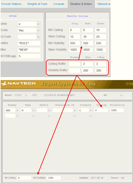
Criteria (Airport use)
While checking for weather suitability, the N-Flight Planning system looks at the planned airports (including the number of alternates) and references the criteria below to determine whether minima values need to be added.
Next, N-Flight Planning determines whether “Normal” or “Alternate” scenarios are to be used based on the Airport Usage, number of alternates specified for that flight, and the number of engines on the aircraft.
Note: Keep in mind that only stations with runways longer than 7000 feet will be considered.

If the N-Flight Planning system determines that the flight meets the “Alternate” criteria, it then looks at the number of runways for the airport(s) where the flight could potentially land.
Note: N-Flight Planning also needs to know how many separate runways are available at these airports so that the correct minima is applied if required.

The Airports database supplies this information, see below.

If the system determines that it should use the Alternate scenario, then it looks at the number of Runways for the Airport.
Whether an airport has separate runways will be determined based on the number of available runways at ETA.
Note: A new field, called Separate, which lists the number of separate runways, and has been added to the FOMS 105 menu.