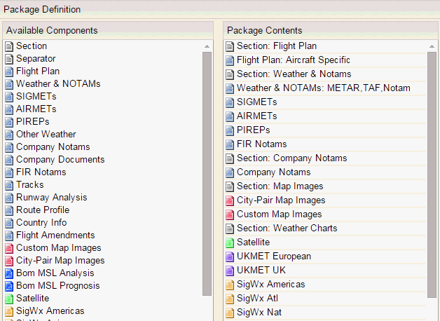
Package Definition group, together with the Package Name group, allows you to determine the components within a flight package layout.

The Package Definition group consists of two lists:
Available Components List
The Available Components list is a list of components that can be included in flight package layouts. To add a component from the Available Components list, drag the desired component into the Package Contents list where it can be configured.

In general, the components correspond to the high-level nodes in the current tree view in the Flight Package Layout group. The exceptions to this rule are marked with an asterisk below.
Component | Description |
Section* | This denotes the start of a new section (corresponding to a PDF bookmark). Components between two Section components will be included in a PDF bookmark whose name is the same as the name of the first Section component. |
Separator | This component has three options: Page Break - start next section on a new page Line Feed - start next section on a new line Single Sided Page Break - start the next section on an odd page if the previous section ends on an odd page. A message displays (set in the main parameter file) to indicate that the page is blank on purpose.
|
Flight Plan | If the Flight Plan node is set as Aircraft Specific, the flight package layout uses the format specified in FOMS Menu 220 (Aircraft Characteristics Program) for the loaded flight’s aircraft. If no value is provided in FOMS Menu 220, the fallback format specified in FOMS Menu 170 (Airline Parameter File) is used.
If the Flight Plan node is set to a specified format, that format is displayed. Display first leg only in multi-leg brief: when selected only the first leg of a multi-leg brief is added to the flight package.
Note: Switching between flight package layouts will not keep changes. For example If a user loads flight package layout A, makes some changes in the tree view, loads layout B, and reloads layout A again; the changes will be lost (in fact they had already been lost when switching to layout B). |
Atc form | Adds the CA48 - ATC ICAO form to the flight plan. See CA48-ATC ICAO form for information on how to use and make the ATC ICAO form editable. |
Weather & NOTAMs | The METARS, TAFs, and NOTAMs of the Weather and NOTAMs tree view nodes are merged into one component to allow you to sort and display results as you require. |
METAR Buffer Time | When added, the METARs on the flight package are filtered to include only ones that fall within ETD - X for departure and ETA - X for enroute/reclear/destination/alternate airports. If no METARs are available within the buffer period, none are included in your flight package. |
Order Enroute Airports By: | Options are Airport Usage Type and Distance from Origin. If Airport Usage Type is selected, the default logic of ordering by station type is used. If Distance from Origin is selected, the enroute (ETP/ETOPS/EEP/EXP/EnrouteWX) stations will be ordered by proximity to the origin. |
Origin, Destination, Alternates, and Others: | Selecting or deselecting a checkbox allows users to include or exclude METARs for an airport. If an airport falls into more than one of these groups, you must uncheck all boxes that it belongs to. For example, if CYYZ is both an ETP station and an alternate, it will still appear in the flight package if only Alternates is unchecked. |
SIGMETs | This component includes SIGMETs in the flight package. |
AIRMETs | This component includes AIRMETs in the flight package. |
PIREPs | This component includes PIREPs in the flight package. |
Company NOTAMs | This component includes Company NOTAMs in the flight package. |
FIR NOTAMs | This component includes FIR NOTAMs in the flight package. |
Tracks | Selecting Tracks includes tracks in the flight package. Several types of tracks are available to be selected: |
Runway Analysis | NFP allows integration of third-party (AeroData) runway analysis data if your NFP environment is configured to do so. The reports that are pushed to NFP from AeroData can be viewed in the Runway Analysis branch on the Reports tree. If the system is not configured for this functionality, the Runway Analysis branch will not be displayed. Contact NAVBLUE Support for more information. |
Route Profile | Selecting Route Profile allows you to incorporate graphic representations of available flight levels and available flight levels showing distance and wind components into the flight package. Three profiles can be selected: available flight levels available flight levels showing distance available flight levels showing distance, wind components, tropopause and MORA.
|
Country Info | The Country Info branch allows the user to select permit-related information for inclusion in the flight package. There are two options: Permit report, which adds the permit report to the flight package Overflight report, which adds the overflight charges to the flight package.
|
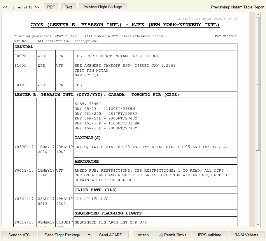
Notam Table report | When added to the Package Contents, notams are displayed in a table format like the example shown below. You can also attach company documents and images to the report. Company documents are displayed in the general section and images are added before the table. |
Map Images* | Choose Select All to automatically add images to the flight package. The following options are available: City-Pair Map Images - This is a placeholder for city-pair map images matching the city pair. Standard Map Images - This is a placeholder for standard map images for all flights. City-Pair Map Images - This is a placeholder for city-pair map images for the flight.

|
Weather Charts* | Weather charts are divided into several components. Each component matches the lowest folder from the current tree view. For example, the current European tree folder in the UKMET tree folder corresponds to the UKMET European component. To facilitate identification, icons for related weather charts are color-coded.
Several types of weather charts are available to be selected: Sat Asia Sat South Pacific Sat Europe Sat Goes E Sat Goes W Sat Meteo 5 Sat Meteo 8 UKMET MeteoFrance SigWx Americas Atl Nat Australasia Pacific South Pacific North Pacific ICAO Area M Pacific ICAO Area F Asia Mid East Europe Europe-Africa Eurasia India BW South Indian South Asia India Colour
BOM Icing SigWx Grid Point Winds MSL Analysis MSL Prognosis
Winds
|
Package Contents List
The Package Contents list displays the actual contents of the selected flight package layout.

Dragging a component from the Available Components list and dropping it in the Package Contents list will include it in the flight package layout. The same component can be included multiple times (e.g.: various Flight Plan components in the same or different formats). Items can be removed by dragging and dropping them in the Available Components list. To reorder items, users can drag and drop them at the desired position in the list.
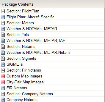
Adding a component or double-clicking an existing one from the list opens a configuration dialog with configuration options specific for that component, as shown in the following illustration.

All configuration dialogues include an Apply button which, when clicked, applies the changes and closes the dialog. Clicking anywhere outside the boundaries of the dialog will close it without applying any changes.
The SIGMETs, AIRMETs, PIREPs, FIR NOTAMs, Company NOTAMs, and Runway Analysis components are not configurable. Double-clicking any of these will not open a configuration pop-up. Double-clicking weather chart components opens a dialog that displays the names of the charts applicable to that particular component. For example, the SigWx Americas component shows the following label:

A Show Route checkbox, when selected, allows you to select to show the route over the weather chart. An Auto Select checkbox, when selected, automatically selects the weather chart to be used in the flight package if it meets the following criteria:
the flight path crosses the area that the chart covers
the flight cruise level is within the flight level that the chart covers
the flight time intersects with the chart's valid forecast time range
Note: When N-Flight Planning automatically selects SigWx charts, it uses those charts that best ensure full coverage of the route. Consequently, some charts may be excluded from the resulting package if another chart already covers the same portion of the route.
The following details the configuration options for the configurable component.
Section: This dialog contains a text box for the section name limited to 30 alphanumeric characters (including spaces), which is empty by default. If the textbox is empty when the popup’s Apply button is clicked, the operation will fail, the dialog will not close and the following error message will be displayed in the status bar: "Invalid section name." Section names are required to be unique within the same flight package layout. Therefore, attempting to create a new section with a name already used by the loaded layout will fail and display the following error message: "Duplicate section name."
Flight Plan: This dialog contains a dropdown list containing Aircraft Specific (the default) plus one entry for each available format. Highlighting keywords can also be customized with bold, italicized and colored text.
Weather & NOTAMs: This dialog contains checkboxes for METARs, TAFs, and NOTAMs. Highlighting keywords can also be customized with bold, italicized and colored text.
Other Weather: This dialog contains a text field to allow you to add a customizable queries to display in the flight package contents.
Tracks: This dialog contains a dropdown list containing NAT, PAC, AUS, NOR and CEP options.
Route Profile: This dialog contains a dropdown list containing Available FLs, Distance FLs, and Distance and Graphical Winds options.
Country Info: This dialog contains a dropdown list containing Permit Report and Overflight Charges options.
For added visibility the text for a Section component list item includes its name (e.g., Section: Charts). Similarly, the text for a Flight Plan component list item includes the selected format (e.g., Flight Plan: Format 03).


